The partners of the European EFHERA project, focused on improving post-fire hydrological and environmental recovery in agroforestry areas, have met in Zaragoza to analyse the progress of this initiative, which is working on the creation of a digital tool that will enable the accurate identification of areas at greatest risk of land degradation.
EFHERA is a project under the Interreg Sudoe programme involving Spain, France and Portugal, with funding of €1.4 million. Led on the technical side by a research group from the Aragón Engineering Research Institute (I3A) at the University of Zaragoza, it is coordinated by the Directorate-General for Forest Management of the Government of Aragón.
The partners met today at the Río Ebro Campus of the University of Zaragoza. At the meeting, they analysed the progress of this project. Researchers at the I3A are working to develop a digital platform for use by those responsible for restoring forest areas after fires. ‘The aim is to provide them with a tool to support their decisions, enabling them to calculate or simulate future scenarios and obtain quantitative data on how these areas would evolve, based not only on their experience but also on scientific data,’ explains Sergio Martínez, from the I3A's Fluid Dynamics Technologies Group.
The research group's objective is to ensure that these calculation models ‘support decision-making, providing data that can be useful when managing fire situations,’ says Sergio Martínez, who recalls the magnitude of recent fires, ‘They are getting bigger and bigger and require very thorough planning of which areas to act on, how, what are the dangers of soil loss in each area, what is the potential for erosion, all that kind of thing.’
Fires cause a great deal of disruption. Not only do they destroy vegetation, they also degrade the soil. And that soil then has certain characteristics that make it more susceptible to erosion and loss of its fertile layer. ‘Very few applications have been developed for these scenarios. Sometimes programmes that were designed for situations without fires are used,’ notes the I3A researcher.
The current focus is on developing highly advanced, high-resolution models to facilitate work on large fires where it is difficult to cover the entire area that has burned. EFHERA is the culmination of a line of work that began in the computational hydraulics section, with computational models to study sediment transport and erosion, but in fluvial environments, in rivers and floods.
Four years ago, they decided to adapt these models to other types of situations, one of which is soil loss due to rain and runoff after fires. To do so, they received funding through an I3A Impulso project and an Innovation project from the Government of Aragon. Now, those first steps are culminating in this Interreg Sudoe project.
The main coordinator of EFHERA is the Directorate-General for Forest Management of the Government of Aragon, through SARGA. There are eight main partners and eight beneficiary partners. In Spain, in addition to Sarga, the University of Zaragoza, I3A as the main technical partner, the Provincial Council of Ávila, the University of Salamanca and the Aula Dei Experimental Station of the CSIC. In Portugal, the University of Évora is the technical partner and the Algarve Intermunicipal Community, AMAL, is the field partner. In France, the University of Pau is also involved. In addition, they have the support of eight collaborating partners, institutions, organisations and companies interested in this initiative.
Pilot actions in Spain, France and Portugal
 To determine its effectiveness, three to four pilot actions are planned in areas affected by fires in recent years in the three countries of the SUDOE zone. The Fluid Dynamics Technologies Group works in the field. Starting with georeferenced information, such as topography, amount of vegetation and soil type, they calculate equations that provide a solution distributed in space and time for a number of variables.
They will be able to project what might happen after such events in 10 years, 50 years, 100 years, 200 years. They can simulate what rainfall would be like across the entire area affected by the fire, taking into account the characteristics of the vegetation and terrain in these fires. They can also see how that rainfall would turn into runoff on the ground and how that runoff would wash away material, erode the hillside, transport sediment and soil, and where it would be deposited. In this way, quantitative data could be obtained on which slopes and which areas of the entire burned area, which may exceed 5,000 or 10,000 hectares, would lose the most soil in the event of extreme events.
And one more step: seeing where that soil would be deposited, "because it's not the same if the soil is torn from a hillside and ends up a little further down in the riverbed or on some kind of plain, as if that sediment, for example, reaches a reservoir. Because reservoirs silt up, causing problems. We want to be able to estimate not only the area itself, but also the impact of erosion downstream," explains Sergio Martínez.
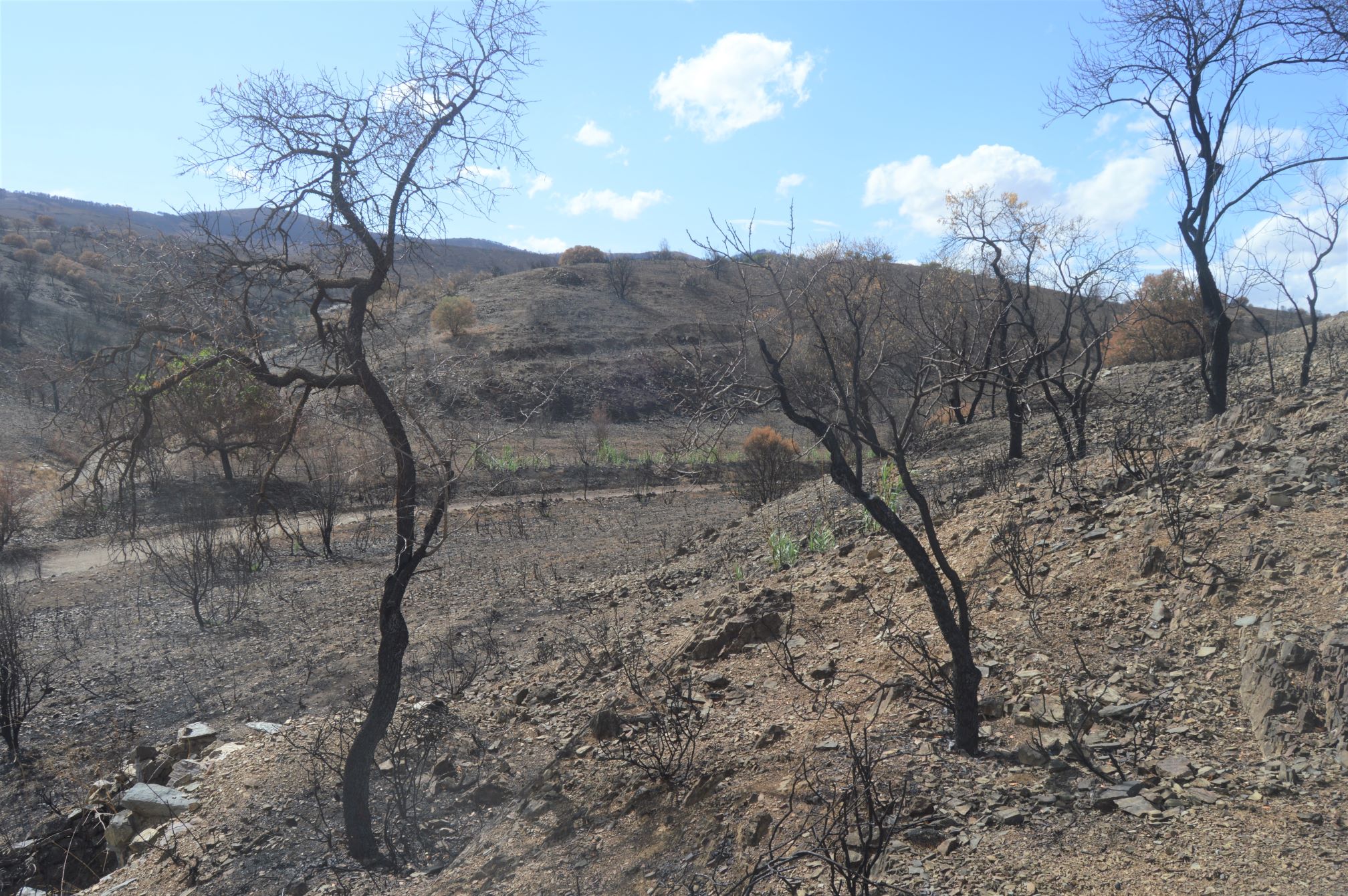
Photograph of the area of the fire in Ateca: Álvaro Hernández